Scattered showers and thunderstorms are expected to sweep into South Florida on Monday as a cold front approaches the region.
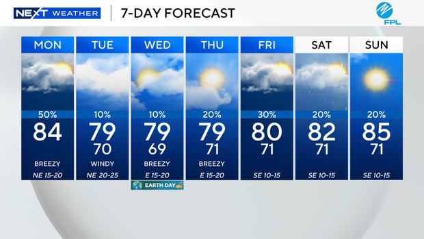
We enjoyed a dry, calm start to the new workweek on Monday, and high temperatures are expected to climb into the low 80s before the wet weather rolls in.
CBS News Miami
The rain is expected to be more widespread around mid- to late-afternoon and evening.
Some of the storms on Monday could be strong and produce heavy rain and gusty winds.
As winds increase later on Monday, the National Weather Service said there will be a high risk of rip currents along the Atlantic beaches as of 2 p.m., and a small craft advisory will go into effect at 2 p.m. Monday.
CBS News Miami 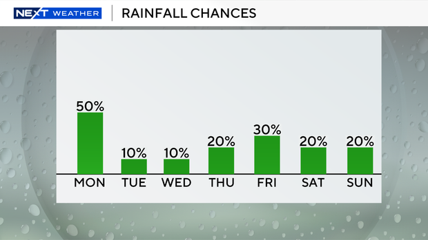
Once the front clears on Monday night, drier and cooler air will move in.
Low temperatures will fall into the low 70s and upper 60s overnight.
CBS News Miami 
On Tuesday, it’s expected to be windy and pleasant with high temperatures in the upper 70s.
Wind gusts could reach 30 mph or stronger.
The windy weather will lead to hazardous beach and boating conditions. There will also be a dangerous high risk of rip currents from Tuesday to Friday.
CBS News Miami 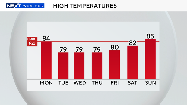
We will stay breezy and pleasant through Wednesday and Thursday with high temperatures remaining below average in the upper 70s.
The chance of rain will stay low through midweek, too.
Temperatures will increase slightly later this week as high temperatures climb into the low 80s on Friday and Saturday with spotty showers possible.
CBS News Miami