
The coldest air of the season is on the way to South Florida.
The CBS Miami Next Weather team is tracking a strong cold front set to usher in arctic air and chilly temperatures Monday night into Tuesday morning.
Monday morning is mild and muggy with temperatures in the mid to upper 70s. A cloudy, warm and breezy day is ahead with highs in the low 80s. A few stray showers will be possible as the front moves through, but the chance of rain is low.
Winds will increase ahead of and along the front with gusts as high as 20 to 25 miles per hour. The gusty breeze is leading to hazardous beach and boating conditions. There is a dangerous high risk of rip currents along the Atlantic beaches through Thursday evening, making it unsafe to go swimming in the ocean. A small craft advisory is in effect for boaters along the Atlantic waters and the Keys waters.
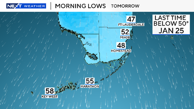
The cool down begins this evening as temperatures will begin to tumble to the 60s. But temperatures will drop drastically overnight as lows will fall mostly to the upper 40s and low 50s by Tuesday morning. Residents across South Florida will need to bundle up Tuesday morning since it could feel even colder when you factor in the wind chill. The last time lows dropped below 50 degrees was back in January of 2025.
As highs are expected to remain in the upper 60s, it could be one of the coldest Veterans Day on record. It will stay cool and breezy throughout the day on Tuesday.
This will be a brief cold snap since lows will be around 60 degrees by Wednesday morning with highs in the low to mid 70s in the afternoon.
By late week and into the weekend, lows across South Florida will be milder in the upper 60s and low 70s. Highs will climb back to the low 80s by Friday, Saturday and Sunday.


