The CBS News Miami NEXT Weather team is tracking two wildfires burning in western Broward and southern Miami-Dade counties that could reduce visibility and air quality for parts of South Florida on Monday.
CBS News Miami
The Max Road Fire near US-27 in western Broward County has burned 5,000 acres and is 20% contained.
The smoke from this fire is moving north and northwestward on Monday morning due to a light southeast breeze, but later on the smoke could hover over parts of western Broward County and then move westward.
CBS News Miami 
The 172nd Avenue Fire in Florida City in southern Miami-Dade has burned 210 acres and is 30% contained.
The smoke from this fire is relatively stagnant on Monday morning due to calm winds, but later on the smoke could lift a bit more northward and impact places like Leisure City and Homestead.
CBS News Miami 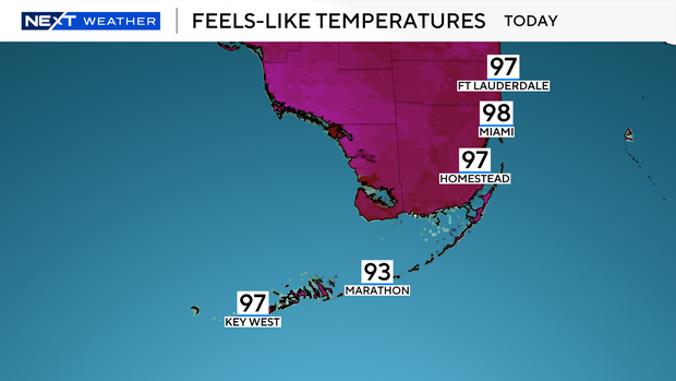
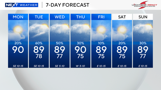
It was a dry and warm start to the day on Monday morning with temperatures in the low to mid-80s. On Monday afternoon, it will be hot and steamy with high temperatures climbing to around 90 degrees.
The feels-like temperatures will be in the upper 90s and triple-digits.
CBS News Miami 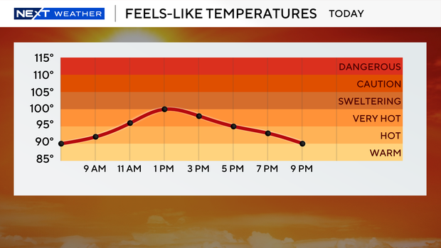
Spotty showers and a few thunderstorms will be possible on Monday, but the rain chances will be even higher on Tuesday.
Any wet weather is welcome at this point as the rain could help in the containment of the wildfires.
CBS News Miami 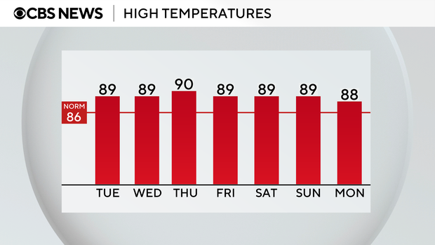
The rain chances will be highest on Tuesday due to a frontal boundary and moisture that’s moving in.
Scattered showers and thunderstorms will develop on Tuesday with the potential for some heavier downpours.
High temperatures will rise into the upper 80s.
CBS News Miami 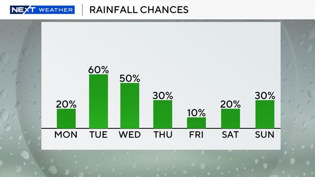
We will remain unsettled on Wednesday with more rain expected. Scattered thunderstorms will move in and lead to heavier rain in some spots.
Keep the umbrella handy on Thursday as passing showers and storms will stick around. High temperatures will remain near 90 degrees.
The chance of rain will decrease on Friday but will rise again over the weekend.
CBS News Miami