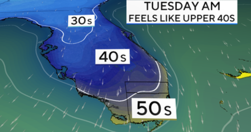
It’s the perfect setup to bring a shot of cold, dry air to South Florida, and it’s happening next week. Monday afternoon the wind will turn northwest and bring in drier air, but it’s not until Monday night that the temperatures really drop.
Temperatures dip into 50s Tuesday morning
By Tuesday morning, residents will step outside to temperatures in the mid‑50s with a northwest breeze that may make it feel like the upper 40s. Plenty of sunshine is expected in the afternoon, but with the northwest breeze reinforcing the cold air, highs may be stuck in the mid‑70s.
Strong front pushes through the state
In order for South Florida to feel the chill, several things must come together. A front strong enough to push through the state is one of them. A cold push of arctic air moving south through the Midwest will trigger an area of low pressure to develop off the Mid‑Atlantic coast early next week. This gives the cold air an added push south, allowing the front to power through South Florida.
CBS News Miami
High pressure builds over other states
High pressure develops in the sweet spot late Monday night — East Texas and Louisiana. This cold core of air will create a northwest wind to the east. That keeps the cold air over land as it moves south through the peninsula. As long as the air stays over land, it can’t warm up or pick up moisture. A northwest wind is what residents will wake up to on Tuesday, along with low humidity and lows in the 50s.
Dry air may linger into Wednesday
That area of high pressure will start to slide east late Tuesday, but the dry air may stick around one more night. Lows may again be in the 50s on Wednesday morning with another pleasant, sunny afternoon.
Ocean breeze returns by Thursday
By Thursday, the ocean breeze should return, keeping overnight lows mild while increasing cloud cover and afternoon temperatures.


