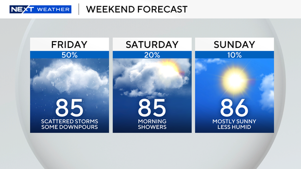
South Florida faces another round of scattered showers and storms Friday before the season’s first fall front arrives this weekend, bringing lower humidity and a drier weather pattern.
The National Weather Service placed the region under a Level 1 risk for flash flooding, warning of heavy downpours that could cause localized flooding. The morning began soggy for the Keys, and rain is expected to spread across Miami-Dade and Broward counties later in the day. Highs will climb into the mid-80s.
A coastal flood advisory remains in effect until 1 p.m. Friday because of ongoing king tides. The next high tides are expected at 11:50 a.m. in Miami, 12:08 p.m. in Fort Lauderdale and 1:33 p.m. in Key West.
Beachgoers are urged to use caution, as there is a high risk of dangerous rip currents along the Atlantic beaches. No advisories are currently in effect for boaters along the Atlantic or Keys waters.
The first fall front of the season will move in Saturday, bringing slightly cooler air and lower rain chances. Morning lows will dip into the low to mid-70s, with highs in the mid-80s.
By Sunday, South Florida will get a brief taste of fall weather, with morning temperatures dropping into the low 70s along the coast and the upper 60s inland. Lower humidity and plenty of sunshine will make for a more comfortable day, with highs staying in the mid-80s.
The drier pattern is expected to continue into early next week with minimal rain chances. The region’s dry season officially begins Wednesday, Oct. 15.