
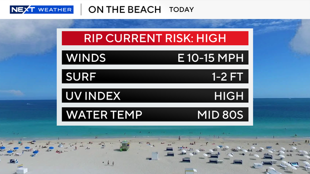
Scattered showers and storms will move across parts of South Florida Tuesday. Highs will climb to the mid-to-upper 80s in the afternoon, and it will be breezy at times. Wind gusts could reach 25 to 30 mph.
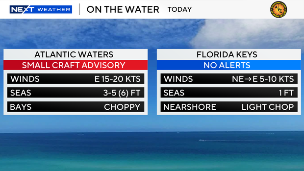
The strong onshore breeze is leading to hazardous beach and boating conditions. There is a high risk of rip currents along the Atlantic beaches, making it unsafe to swim. There is a small craft advisory for boaters along the Atlantic waters, but there are no alerts or advisories for boaters over the Keys waters.
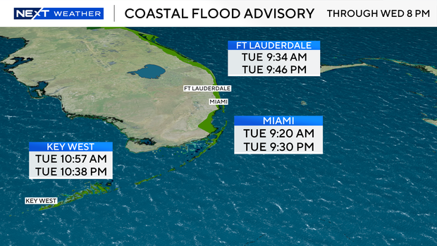
A coastal flood advisory continues through Wednesday, Oct. 8, due to the higher-than-normal king tides. Saltwater coastal flooding will be possible along low-lying areas during high tide times.
The next high tide in Ft Lauderdale will take place at 9:34 a.m. Tuesday and again at 9:46 p.m. The next high tide in Miami will take place at 9:20 a.m. and again at 9:30 p.m. And in Key West, the next high tide will take place at 10:57 a.m. and then again at 10:38 p.m.
The king tides are made worse by east winds pushing water onshore. The strong onshore wind piles water along the coast, sending the tide higher.
South Florida remains unsettled Wednesday, with more passing showers and storms around. Highs will stay in the upper 80s. The chance of rain rises late week on Thursday and Friday with scattered storms expected daily.
A cold front is forecast to move in this weekend, which will lower our rain chances and lower our humidity. Some drier air will give us a slight taste of fall since it will not feel as muggy. Highs will climb to the mid-80s on Saturday and Sunday.


