
Tuesday, the final day of September, will be drier and breezy across South Florida.
Gusty winds up to 25 mph or stronger will be possible as Hurricane Imelda remains close enough to Florida. Drier, stable air will settle in and lower rain chances since South Florida is on the western and outer edges of Imelda’s counterclockwise circulation.
Abundant dry air in the mid to upper levels of the atmosphere will suppress any widespread storm development. Only a few showers are possible, and they will likely move through quickly.
With less cloud coverage, more sunshine and less rain around, it will be hotter Tuesday. Highs will soar to the low 90s by the afternoon, and near record heat will be possible.
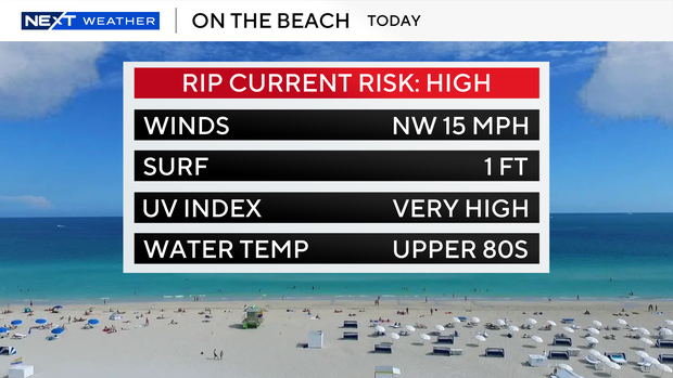
As Imelda moves northeastward and away from the U.S. coastline, South Florida will still be dealing with indirect impacts along the coast. Hazardous beach and marine conditions continue.
A dangerous high risk of rip currents will continue through late Wednesday night, and it is not safe to go swimming in the ocean.
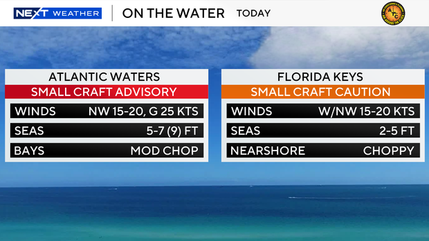
A small craft advisory is also in effect for boaters along the Atlantic waters through early Thursday morning due to rough conditions, north-northwest winds of 20 to 25 knots, and 7-to-10-foot seas. A small craft caution is in effect for the Keys waters due to choppy conditions nearshore.
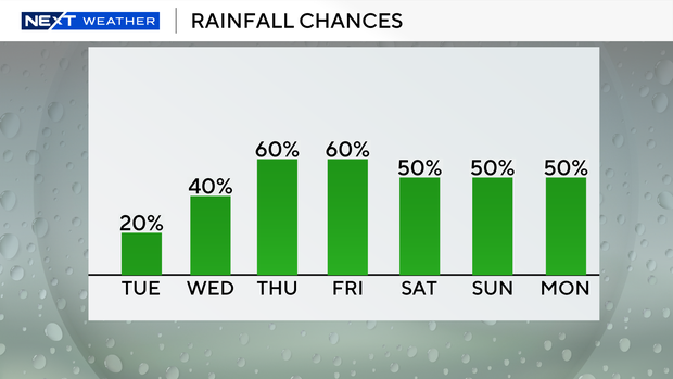
The winds will begin to lighten by Wednesday. The chance of rain will increase with more wet weather around.
Scattered showers and storms will move in with the potential for some heavy downpours. Highs will climb to around 90 degrees Wednesday afternoon.
It is looking like it will be a soggy start to the month of October as moisture moves in and enhances rain chances to end the week and into the weekend.
Scattered storms will be possible every day. With more wet weather and cloud coverage around, it will not be as hot. Highs will rise to the upper 80s.


