As Tropical Storm Imelda passes to the east over the Bahamas, South Florida will be dealing with indirect impacts.
Most are waking up to mainly dry conditions Monday, but later some gusty showers will be possible as the breeze builds.
Imelda will be close enough to create an increased pressure gradient, and it will be windy at times with gusts as high as 25 to 30 mph.
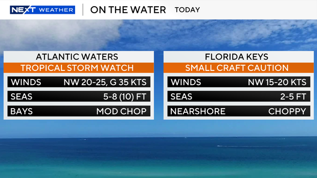
Hazardous marine conditions are expected Monday through midweek. A Tropical Storm watch and a small craft advisory are in effect for the Atlantic waters. A small craft caution is in effect for the Keys waters due to choppy conditions.
There is also a dangerous high risk of rip currents for coastal Miami-Dade, coastal Broward, and coastal Palm Beach counties through late Wednesday night. It is not safe to go swimming in the ocean due to the rip currents and rough surf.
Highs will climb to the upper 80s Monday under mostly sunny skies. It will feel like the mid to upper 90s this afternoon when you factor in the humidity.
South Florida stays breezy on Tuesday with wind gusts as high as 25 to 30 mph. The chance of rain will be lower Tuesday due to drier air filtering in across South Florida as Imelda continues to lift northward. It will eventually move northeastward away from the U.S.
Some quick showers will be possible, but the rain will not be widespread. As the winds shift more out of the west, we’ll heat up to around 90 degrees.
Wednesday will be breezy but not as blustery as the start of the week, as Imelda will continue to push further away from South Florida. It will be mostly sunny with northwest winds around 15 mph with gusts as high as 20 mph. Passing showers and storms will be possible.
By late week, deeper moisture will move in and increase the chance of rain as we kick off the month of October. Scattered storms are expected Thursday through the weekend with a slight decrease to the mid to upper 80s for daily high temperatures.