
Humberto, the eighth named storm of the 2025 Atlantic hurricane season, strengthened into a hurricane late Thursday night, but it is not expected to impact South Florida, meteorologists say.
Where is Humberto?
As of 5 a.m. Sept. 26, Humberto is located about 465 miles northeast of the Northern Leeward Islands, moving northwestward at 3 mph with maximum sustained winds of 75mph.
Humberto becomes a hurricane
Hurricane Gabrielle broke a near-month drought in the Tropics. Now, Humberto, like its predecessor, is the next hurricane of the season, making it only the third to gain that intensity.
In the coming days, Humberto will be steered along the southwestern edge of the ridge of high pressure in the north-central Atlantic.
This weekend and early next week, an approaching trough moving offshore the East Coast of the United States will begin to break down the ridge and allow the system to turn north.
It is a complicated forecast with steering and timing differences, including the approaching trough and potential interaction with a tropical wave farther east.
As of now, Bermuda must remain vigilant of the storm’s evolution.
Tropical wave over Puerto Rico
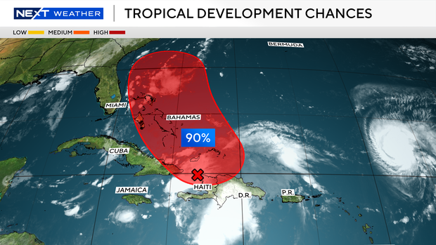
The tropical wave over Puerto Rico will pose the greatest forecast challenge as it approaches the Bahamas and then continues east toward Florida.
This disturbance is producing heavy rain and gusty winds across portions of the Dominican Republic and the Turks and Caicos Islands. An area of low pressure is expected to form along the wave tonight or early Friday when it moves near the southeast Bahamas.
This low is expected to become a tropical depression when it is in the vicinity of the central and northwest Bahamas in a couple of days. The National Hurricane Center is now giving this system a high potential of development over the next two to seven days. A dip in the jet stream is forecast to keep this area east of Florida, but it is too early to tell what, if any, impacts there could be in South Florida.
Models show limited South Florida threat for what could become Tropical Storm Imelda
Models are in good agreement that the system will also turn north before any significant impacts across South Florida.
After that, it is uncertain what will happen as steering currents become erratic.
The U.S. GFS model shows a sheared system from strong upper-level winds over Florida, while the European model has it getting trapped with no steering and then making an unusual turn back to the U.S.
2025 Atlantic hurricane season
NEXT Weather ![]()
The National Oceanic and Atmospheric Administration, or NOAA, forecast an above-normal hurricane season this year, predicting there will be between 13 and 18 named storms. Five to nine of those are expected to become hurricanes.
Erin was the first, and so far only, storm to become a hurricane this season. Erin didn’t make landfall, but at its peak grew to a ferocious Category 5, and it caused strong winds, dangerous rip currents and flooding along parts of the East Coast.
Historically, on average, hurricane and tropical storm activity peaks on Sept. 10, but this year has been quieter than expected when it comes to tropical systems in the Atlantic.


