
Thousands of Broward County public school students headed back to class for the start of the new year on Monday.
It was a warm and muggy start to the day with temperatures in the upper 70s and low 80s. With less rain around, it will be hotter than the previous few days with highs climbing to the low 90s. It will feel like the low 100s when the humidity is factored in.
As high pressure builds and drier air settles in, the chance of rain is low with only spotty showers developing on the breeze. The heaviest rain will be steered towards the interior and the West Coast.
There is a high risk of rip currents along the Atlantic beaches and the UV index is extreme. There are no alerts or advisories for boaters along the Atlantic or Florida Keys waters.
NEXT Weather 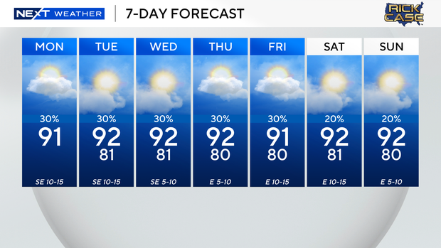
High pressure will remain in control for the rest of the week, keeping the chance of rain low with more of a typical summer-time pattern. A light easterly-southeasterly wind flow will lead to a more seasonal pattern with some passing showers possible each day on the breeze.
This week will be a scorcher with highs soaring to the low 90s and feels-like temperatures in the triple-digits. The National Weather Service said heat advisories may be issued if the heat indices are forecast to reach 105 degrees or higher for two hours or more.
The summer sizzle continues through the weekend with the potential for scattered showers on Saturday and Sunday.


