
South Florida’s hot and dry weather pattern is in for a change over the next few days as the rain returns and brings some relief from the heat.
On Tuesday morning, temperatures hovered in the low 80s across the region. With the heating of the day, they will climb into the lower 90s for the afternoon. Despite “feels like” temperatures returning to the triple digits for the early afternoon, no heat advisories are in effect for South Florida. Heat index values, which take into account the temperature and the humidity, will range from the upper 90s to 103 degrees.
The National Weather Service issues a heat advisory when the heat index is expected to reach 105 degrees, or higher, and last for at least two hours.
NEXT Weather 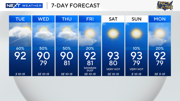
The NEXT Weather team is tracking a 50-60% chance of scattered showers and storms in the afternoon on Tuesday, favoring Broward and Miami-Dade counties, as moisture moves in from the east. The chance of rain will drop after sunset. On Wednesday and Thursday, there is a 50% chance for scattered showers and storms.
By Friday, Saharan dust and drier air will move in. This will lower the chance of rain for the weekend and bring back hotter conditions with afternoon highs in the lower to mid-90s.


