
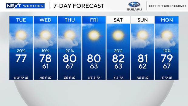
After a wet and messy Monday, South Florida woke to a drier start on Tuesday.
Temperatures ranged from the low 60s inland to the mid to upper 60s along the coast in Broward and Miami-Dade due to a northern breeze. It was a milder start for the Keys with the temperatures low 70s.
Although the chance of rain remains low, a few showers will be possible. Highs will climb to the upper 70s in the afternoon under partly sunny skies.
Wednesday morning we’ll wake to the low 60s. Highs will climb to the upper 70s with only a 10% chance of rain.
High pressure will slide into the Gulf and a much drier air mass will lead to a more quiet pattern midweek.
Thursday we’ll wake to the upper 60s and highs will warm to around 80 degrees with the potential for a few spotty showers, however the overall chance of rain remains low.
NEXT Weather
Another cold front will move across the southeast and eventually make its way into the northern Florida peninsula on Thursday. However, it will likely weaken and fizzle out by the time it makes it to South Florida on Friday. Although we will not experience a big drop in temperatures, the humidity will be a little lower.
As high pressure builds in, we will enjoy mainly dry conditions for the final weekend of February.
Friday morning lows will fall to the low 60s, with seasonal highs in the upper 70s in the afternoon.
Low temperatures on Saturday and Sunday will remain comfortably cool, we’ll wake to the low to mid 60s. Highs will climb to around 80 degrees with only isolated showers possible.


