
Near-record heat is in the forecast across South Florida for Sunday and the beginning of next week, but a major cooldown is just around the corner.
After a mild start in the lower 70s for most, temperatures climb to the lower to mid-80s across the area Sunday afternoon. While a 10% stray shower chance will be possible, most remain dry and breezy with winds between 10 to 20 mph possible. This breeze will bring a high rip current risk for our beaches this afternoon.
Temperatures warm up even more for Monday afternoon as highs peak in the lower to mid-80s once again. The daily heat record of 85 degrees will be challenged for Miami on Monday. Enjoy the warmer weather now, because a strong cold front pushes through the region on Monday, bringing colder air by Tuesday morning.
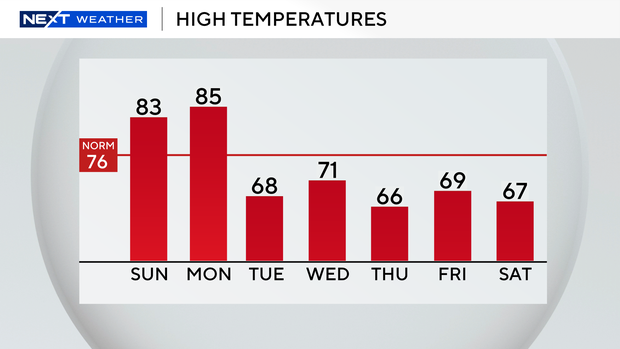
We’ll wake up to temperatures in the lower to mid-50s Tuesday morning. Afternoon highs will struggle to make it to the upper 60s Tuesday afternoon. The winter chill sticks around for the rest of the workweek and upcoming weekend as highs remain well below average with afternoons mostly in the upper 60s. The coldest mornings are currently forecast to be on Thursday and Friday mornings in the mid to upper 40s.
Rain chances will be slim over the next seven days with just a 20% isolated shower chance on Monday ahead of the cold front moving through.


