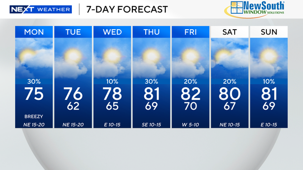
It’s going to be a windy and cooler start to the week, but temperatures will be on the rise as the week continues.
A Wind Advisory is in effect until 7 pm for Broward and Miami-Dade due to sustained winds of 20 to 25 miles per hour and gusts as high as 35 miles per hour.
The highest winds will take place this morning through mid-afternoon. The gusty winds could lead to difficulty driving for high-profile vehicles.
The National Weather Service says the blustery conditions may also lead to fallen or falling tree debris and unsecured items can be rolled or tossed.
It is cooler this morning with lows in the 60s. We are waking up with some rain in spots. Highs will struggle to reach the mid 70s this afternoon due to the clouds and passing showers on the breeze.
The windy weather is also leading to dangerous beach and marine conditions. It is not safe to go swimming in the ocean.
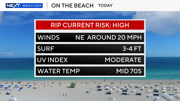
A High Surf Advisory has been issued for Fort Lauderdale beaches through 1 am. There is a high risk of rip currents along the Atlantic beaches through Thursday evening.
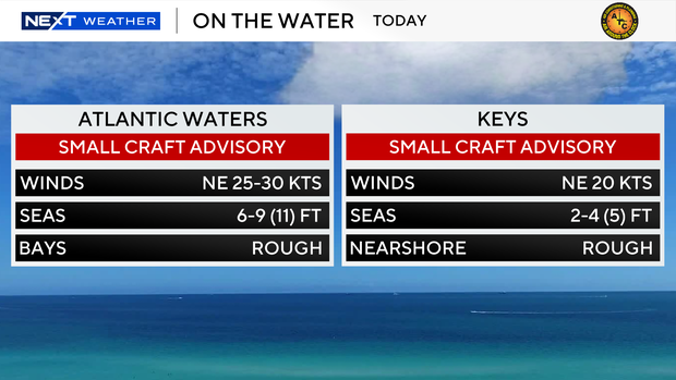
A small craft advisory has been issued for the Atlantic waters and the Keys waters due to rough conditions out on the water.
Tuesday morning will be cooler with lows dropping to the low 60s and upper 50s inland. It will be cooler closer to the coast as well with lows in the mid to upper 60s.
It will not be as windy but still breezy with gusts reaching up to 20 miles per hour. We’ll enjoy more sunshine and highs will climb to the mid 70s.
Wednesday will be slightly milder with highs in the upper 70s as winds begin to shift out of the east. The ocean breeze will moderate the temperatures. The wind will be lighter 10 to 15 miles per hour.
Late week into the weekend we’ll warm back up with lows close to 70 degrees and highs in the low 80s.
Spotty showers will be possible through Saturday and Sunday.