
Slightly cooler this Wednesday morning with lows falling to the mid 60s inland and low 70s along the coast. Some patchy dense fog has reduced visibility in spots.
We will enjoy more sunshine later today and highs will climb to the low 80s. It will not be as warm today in comparison to yesterday as we tied record highs in the upper 80s in Miami and Ft. Lauderdale.
Although the chance of rain is low, a few isolated showers will be possible later.
There is a moderate risk of rip currents along the Atlantic beaches. There are no alerts or advisories for boaters along the Atlantic or Keys waters.
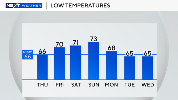
Tonight will be even cooler as temperatures will tumble overnight to the low 60s inland and the mid to upper 60s closer to the coast. Thursday afternoon highs will climb to the low 80s with plenty of sunshine and mainly dry conditions. This is a brief dip in degrees as we will warm up as we head into the weekend.
By Friday morning lows will be milder in the low 70s and highs will be seasonable in the low 80s. Even warmer on Saturday as highs soar to the upper 80s and we may tie or break some records again.
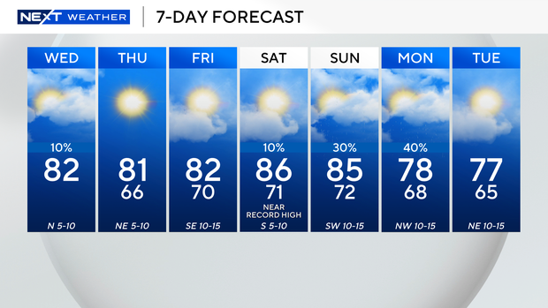
The chance of rain rises Sunday ahead of our next cold front. It will be warm and humid with highs climbing to the mid 80s with the potential for spotty showers. Lows will cool down to the upper 60s by Monday morning. Highs will be below average in the upper 70s with scattered showers possible. Even cooler by Tuesday morning with lows falling to the mid 60s. Highs will remain pleasant in the upper 70s.


