It will be a bit warmer both Monday and Tuesday, with slightly stickier conditions due to humidity.
Scattered showers will be possible on the breeze, but the chance of rain is not high.
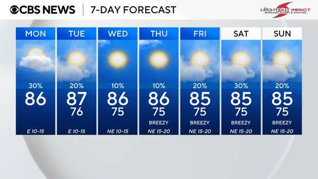
South Floridians woke to temperatures in the upper 70s. Highs will rise to the mid to upper 80s by Monday afternoon.
A coastal flood statement remains in effect through 8 p.m. due to minor coastal flooding possible for Miami-Dade, Broward and Palm Beach counties. Minor flooding of low-lying coastal areas will be possible within one and a half to two hours of high tide. Residents across South Florida should not drive through saltwater flooding.
There is a dangerous risk of rip currents through 8 a.m. Tuesday, along the Atlantic beaches, but later Monday, there is a moderate risk of rip currents. There are no alerts or advisories for boaters over the Atlantic waters or the Florida Keys waters.
The east breeze stays with us through Tuesday with the potential for spotty showers. A stalled frontal boundary will keep plenty of moisture around, and it will stay humid. Highs will climb to the upper 80s.
Drier air moves in midweek to lower humidity and lower the chance of rain, with only a few stray showers possible. Highs will be closer to the mid-80s.
Late week and into the weekend, the chance of rain will increase with spotty showers possible Friday, Saturday and Sunday. Highs will climb to the mid-80s. The breeze will build out of the northeast and then could carry in some passing showers across parts of South Florida.