
Tropical Depression 9 strengthened into Tropical Storm Imelda on Sunday afternoon, making it the ninth named storm of the 2025 Atlantic hurricane season.
It is now forecast to remain off the coast of the Carolinas as a hurricane on Tuesday and Wednesday.
Where is Imelda?
As of 2 p.m. Sept. 28, Tropical Storm Imelda is located about 95 miles west-northwest of the Central Bahamas and 370 miles southeast of Cape Canaveral, moving northwestward at 7 mph with maximum sustained winds of 40 mph.
Imelda is closely monitored for U.S. threats
Tropical Storm Imelda is showing signs that it may be starting to intensify as it moves northwest away from the coast of Cuba, as its slower movement initially may lead to a quicker turn to the east. The latest tracks are a little farther off the coast, which will likely keep the outer bands north and east of the area.
Here in South Florida, the NEXT Weather team will watch Imelda closely over the next few days as it moves northwest and eventually north-northwest, passing over the Bahamas.
There is still no clear center for the storm and the movement remains uncertain, which means that slight shifts in the track are possible. The storm is expected to strengthen into a tropical storm on Sunday as it moves north over the Bahamas. The current forecast from the National Hurricane Center shows it passing well to our east and becoming a hurricane as it moves north towards Georgia and the Carolinas on Tuesday.
Imelda is likely to move away from South Florida by Monday but could continue to intensify, growing in strength and size.
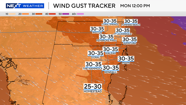
The winds will likely be the strongest on Monday and early Tuesday with gusts of 25 to 30 mph. Gusty showers may impact parts of the area from time to time, but the heaviest rain bands will remain off the coast. Given the location and movement of the storm, the strongest wind will likely be north in northern Broward County.
As the storm nears the Southeast U.S. Coast, what has been steering it north will break down. The forecast track shows it slowing down and just sitting near or just off the coast for a day or two before getting pushed east over the Atlantic by the end of the week. Rough seas and surf will continue here in South Florida throughout the week.
Stay alert for any changes in the forecast as Imelda gets better organized. Once a clear center forms, there will be a better idea of where the strongest impacts will be. A slight change in the forecast track could bring those rain squalls and tropical storm-force winds closer to the coast, potentially impacting some or all of South Florida.
Humberto rapidly strengthens but has no impact on South Florida
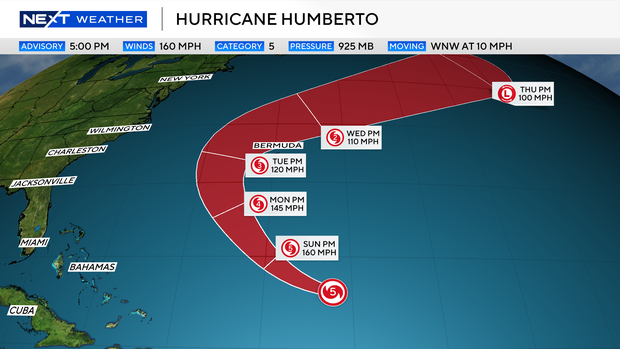
Humberto, the eighth named storm of the 2025 Atlantic hurricane season, quickly strengthened into a Category 5 hurricane on Saturday afternoon before weakening to a Category 4 on Sunday. However, it is not expected to impact South Florida, meteorologists say.
As of 11 a.m. Sept. 28, Humberto is located about 450 miles north of the Northern Leeward Islands and about 535 miles south of Bermuda, moving west-northwestward at 13 mph with maximum sustained winds of 150 mph.
Humberto, like the other two hurricanes of the season, rapidly intensified Saturday as it began a turn to the north, where Bermuda remained on alert.
2025 Atlantic hurricane season
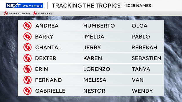
The National Oceanic and Atmospheric Administration, or NOAA, forecast an above-normal hurricane season this year, predicting there will be between 13 and 18 named storms. Five to nine of those are expected to become hurricanes.
Erin was the first, and so far only, storm to become a hurricane this season. Erin didn’t make landfall, but at its peak grew to a ferocious Category 5, and it caused strong winds, dangerous rip currents and flooding along parts of the East Coast.
Historically, on average, hurricane and tropical storm activity peaks on Sept. 10, but this year has been quieter than expected when it comes to tropical systems in the Atlantic.

