
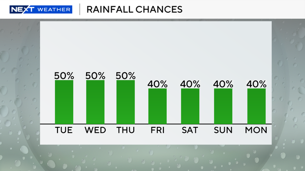
Another round of scattered storms will move in across parts of South Florida on Tuesday.
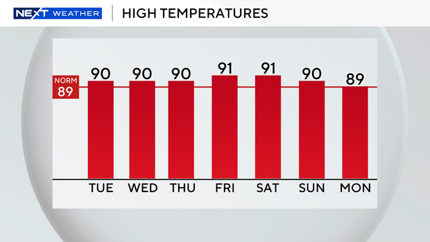
Although South Floridians are waking up to a mainly dry start, a few showers will be possible throughout the morning. Yet, the first full day of fall will feel more like summer with highs around 90 degrees Tuesday afternoon. The feels-like temperatures are in the mid to upper 90s.
Storms will develop by Tuesday afternoon due to the heating of the day and plenty of moisture. Some heavy downpours and localized flooding will be possible.
There is a moderate risk of rip currents along the Atlantic beaches. There are no alerts or advisories for boaters along the Atlantic or Keys waters.
The weather remains unsettled through Wednesday due to a lingering frontal boundary and a very moist atmosphere. Thunderstorms will be driven by the sea breeze during the afternoon and early evening hours. Heavy rain and flooding will be possible with a weak steering flow in place.
Temperatures will be about a degree or so above normal, with highs ranging from the upper 80s to the lower 90s. Lows will be in the mid to upper 70s.
South Florida will transition to a more seasonal pattern late week with the potential for sea-breeze driven thunderstorms in the afternoon and evening. The chance of rain will decrease a bit on Thursday and Friday. Temperatures will remain slightly above normal late week and into the weekend.
This weekend, a frontal boundary may stall out near Lake Okeechobee, allowing the atmosphere to remain saturated.

The CBS Miami Next Weather team will also be monitoring a tropical wave currently east of the Leeward Islands, which has a medium chance of development.
The National Weather Service says that although a surface front and upper-level trough are expected to steer any potential development away from South Florida, some peripheral impacts could be possible. Regardless of development, some of the moisture associated with this disturbance could enhance the potential for more rain.


