
Tropical Storm Erin officially formed in the eastern Atlantic on Monday morning, just west of the Cabo Verde islands.
This system is expected to continue moving west to west-northwest at 15 to 20 mph across the eastern and central tropical Atlantic.
Forecast models have remained consistent on the track continuing west-northwest, staying north of the Leeward Islands over the course of the week.
Early models show the storm is expected to strengthen and could become the first hurricane of the season around Thursday. Some intensity forecasts suggest this could even become a major hurricane by the weekend.
NEXT Weather 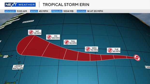
A number of forecast models show a turn to the north and northeast by the beginning of next week. This has been the forecast trend but it could easily shift back to the west. A few forecast models continue the western movement continuing over the weekend, but they remain the minority. Depending on when this turn begins will play a role in whether or not impacts will be expected in the U.S. The NEXT Weather team will continue to provide consistent updates over the week.
The National Weather Service predicted an above-normal season for the Atlantic basin this year with an expected number of named storms between 13 and 18, five to nine of which could become hurricanes.


