
The NEXT Weather team is tracking three areas in the tropics, one of which could become the first hurricane of the 2025 Atlantic season.
A tropical wave in the eastern Atlantic has been given a high potential (90% chance) for development over the next two to seven days by the National Hurricane Center.
This wave continues to get better organized with a well-defined area of low pressure located just to the west of the Cabo Verde Islands. This system is likely to become a tropical depression or Tropical Storm Erin, possibly as soon as late Monday morning.
Locally heavy rainfall and gusty winds are expected to continue across portions of the Cabo Verde Islands. Interests there should monitor the progress of this system.
NEXT Weather
Could be the first hurricane of the 2025 season
This system is expected to continue moving west to west-northwest at 15 to 20 mph across the eastern and central tropical Atlantic. There is still a lot of uncertainty late week and into the weekend regarding exactly where this system will go.
This will be a long track storm which the NEXT Weather team will continue to monitor. Forecast models have remained consistent on the track continuing west-northwest, staying north of the Leeward Islands. This could become the first hurricane of the season with some intensity forecasts suggesting this could even become a major hurricane by next weekend.
Next weekend a number of forecast models continue to show a turn to the north and eventually the northeast keeping it off the U.S. coast entirely. This has been the forecast trend but it could easily shift back to the west, a few forecast models continue the western movement over the weekend, but they remain the minority.
Two other areas being tracked
There are two other areas being monitored but they are not a concern for South Florida.
NEXT Weather 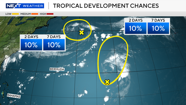
In the Central Atlantic a weak trough of low pressure is only producing limited shower and thunderstorm activity. Significant development of this system is becoming unlikely over the next few days as the system drifts generally northward, remaining over the ocean. The National Hurricane Center is giving this area only a 10% chance of development.
In the Northwest Atlantic, a non-tropical area of low pressure is currently located a few hundred miles to the south-southeast of Nova Scotia, Canada. This system is drifting over the warm waters of the Gulf Stream where some tropical or subtropical development could occur over the next day or two. The National Hurricane Center is giving this system only a 10% chance of development over the next two to seven days. By the middle of this week, the system is expected to move northward over cooler waters, ending its changes for further tropical development.


