
After scattered thunderstorms on Monday afternoon and evening, another round of rain is expected on Tuesday.
Scattered showers and storms moved across parts of South Florida in the morning hours. In the afternoon, some storms will have the potential for heavy downpours and localized flooding.
A previously issued NEXT Weather Alert for Tuesday has been canceled since the Weather Prediction Center lowered the risk of excessive heavy rainfall and flash flooding to a Level 1. However, South Florida remains unsettled with high chances of rain due to a disturbance moving across northern Florida that is providing plenty of moisture.
NEXT Weather 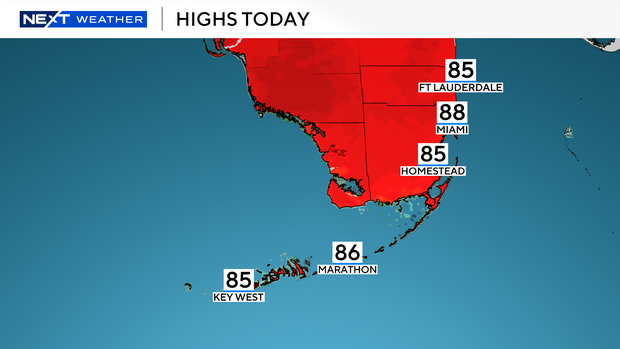
Afternoon high will climb to the mid to upper 80s. On Tuesday, the storms will roll in earlier than they did on Monday. There will be more shower activity around mid-morning with widespread showers and storms expected around midday through the afternoon hours.
On Wednesday, the chance of rain will decrease but spotty storms will be possible. Highs will remain in the upper 80s. Scattered storms are expected on Thursday before the chance of rain goes down for the weekend. A few storms will be possible on Friday through Sunday and highs will soar to the low 90s.
NEXT Weather 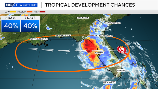
The CBS Miami NEXT Weather team is tracking an area of low pressure located just offshore of the east coast of Florida. The National Hurricane Center has given it a 40% chance (medium potential) of cyclone development over the next 2 to 7 days. It is forecast to move westward across the Florida peninsula on Tuesday and then reach the northeastern Gulf by the middle part of this week. Environment conditions appear generally favorable for additional development and this system may become a tropical depression by the middle to latter part of the week as it moves across the northeastern and north-central Gulf.


