
The NEXT Weather team has issued NEXT Weather Alert Days for Monday and Tuesday for flash flooding threats across South Florida.
The Weather Prediction Center first issued a Level 2 out of 4 excessive rainfall outlook for Monday, but has now extended the threat into Tuesday. That means there is a chance that rainfall could exceed what is needed to cause flash flooding. A flood watch is now in effect for Monday afternoon and evening.
The first half of Monday is expected to be dry, but expect the first round of rain and flood threats to arrive Monday afternoon and into the evening.
CBS News Miami 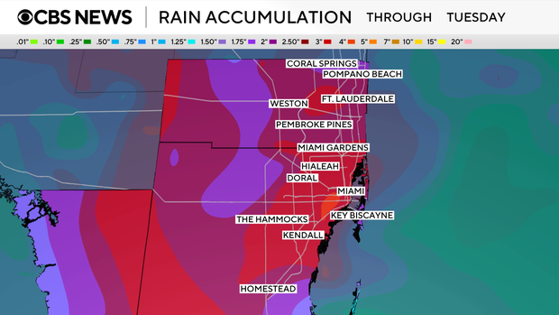
The events are for Monday and Tuesday afternoons and evenings, where up to 4 inches of rainfall can accumulate, with localized higher amounts.
The disturbance will move across the Florida Peninsula and into the Gulf on Tuesday. As it continues to move west it has the potential to develop into a tropical system. The National Hurricane Center has a low development chance but not until middle to late part of this week.
As it moves towards the Gulf coast the heavy rain and flooding risk will push inland and towards the Gulf coast. The Next Weather Team will continue to monitor this potential system and the impacts it may have on our area over the next few days regardless of any tropical development.


