
Scattered showers and storms will move across South Florida on Thursday before drier air moves in just in time for the weekend.
The chance of rain will be highest in the morning through the midday hours, with the potential for some heavy downpours and localized flooding. The atmosphere remains juicy and unstable due to an upper-level area of low pressure which has led to all the wet weather over the last few days.
Afternoon highs will climb to the low 90s, but when the humidity is factored in, it will feel like the upper 90s and 100s.
There is a moderate risk of rip currents along the Atlantic beaches and the UV index is extreme. There are no alerts or advisories for boaters over the Atlantic or Keys waters.
Late Thursday afternoon, a plume of Saharan dust will begin to move and storms will push inland and to the west.
NEXT Weather 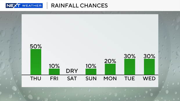
The drier air and high pressure will bring drier, hotter conditions on Friday and through the weekend. It will be a scorcher due to the lack of rain and cloud coverage. Highs will soar to the low 90s and it will feel like the triple-digits. The National Weather Service may issue heat advisories.
Early to middle of next week the chance of rain rises with the potential for passing showers and a few storms.
The National Hurricane Center is monitoring a trough of low pressure over the north-central Gulf that has a low potential (10% chance) of development as it moves generally westward across the north-central portion of the Gulf. Regardless of development, this system is expected to bring heavy rain and the potential for flooding along the Gulf coast.


