
This Fourth of July will not be independent of storms.
While the morning is mainly dry, late morning through the afternoon scattered storms will develop with the potential for heavy downpours. The heating of the day, along with a very moist atmosphere, will help fuel the thunderstorms. There is a marginal risk (Level 1) of flooding in spots.
Afternoon highs will rise to the upper 80s.
NEXT Weather 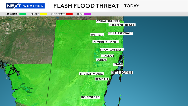
Some storms will be possible in the early evening but the chance of rain decreases later. Around fireworks display times, it should be mainly dry but cloudy.
It will not be a great beach day, with cloudy conditions and storms. There is a low risk of rip currents along the Atlantic beaches and the UV index is very high. There are no alerts or advisories for boaters along the Atlantic and Keys waters, but they’re advised to keep their eyes on the sky as passing storms will be moving in throughout the afternoon.
NEXT Weather 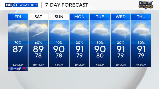
Saturday will have a soggy start with showers and storms in the morning. The wet weather will likely linger through the afternoon with some heavy rain at times. Highs will stay in the upper 80s.
The chance of rain is not quite as high on Sunday but spotty storms will still be possible in the afternoon.
By early next week, the chance of rain decreases to 30% with only a few showers and storms possible on Monday through Wednesday. With less rain around, afternoon temperatures will head back up to around 90 degrees.

