
On Monday, the final day of June, it will be mainly dry with only a few showers and isolated storms possible. The chance of rain is low due to drier air and Saharan dust that will also lead to hazy skies at times.
Monday got off to a mild and muggy start with temperatures in the mid to upper 70s in Broward and Miami-Dade, the Florida Keys saw the low 80s. Highs will climb to 90 degrees in the afternoon under mostly sunny skies and it will feel like the mid to upper 90s when you factor in the humidity.
There is a low risk of rip currents along the Atlantic beaches and the UV index is extreme for the day. There are no alerts or advisories for boaters along the Atlantic waters and Keys waters.
NEXT Weather 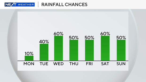
The chance of rain will increase on Tuesday through the rest of the week as July begins with a wet and unsettled weather pattern. Beginning Tuesday, and over the next several days, there will be more showers and storms around due to moisture associated with an upper-level area of low pressure that will move in from the Bahamas.
Late week, an area of low pressure could develop along a frontal boundary near northern Florida. The National Hurricane Center is giving this area a low potential of tropical cyclone development. Regardless of development, all the moisture associated with this system is likely going to bring the potential for widespread showers and storms across the state of Florida.
Although the heaviest rain will likely impact central and northern Florida, South Florida will have the potential for more showers and storms starting Friday for the Fourth of July and heading into the holiday weekend. The CBS Miami Next Weather team will monitor this disturbance and continue to update the forecast as we receive more information.

