
It was a wet start for parts of South Florida on Wednesday as scattered showers moved in on the breeze. It was a warm, muggy start with temperatures mostly in the low 80s.
Highs will rise to near 90 degrees in the afternoon and it will feel like the upper 90s and 100s when you factor in the humidity. As the breeze builds out of the southeast most of the rain will be steered inland to the west.
There is a high risk of rip currents along the Atlantic beaches and it is not safe to go swimming in the ocean. There are no alerts or advisories for boaters along the Atlantic or Florida Keys waters.
NEXT Weather 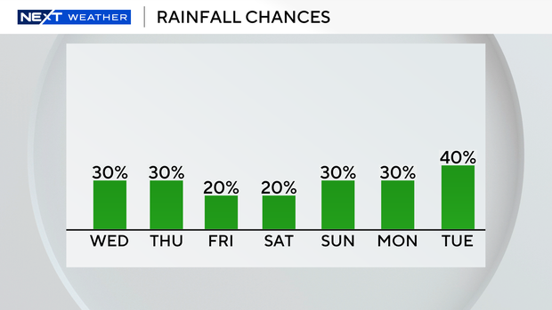
It’s rinse and repeat on Thursday with showers expected in the morning and some storms possible for inland areas in the afternoon. Highs will climb to around 90 degrees in the afternoon. It will feel like the triple-digits when you factor in the humidity.
Friday the chance of rain decreases a bit but some rain will still be possible in the late morning through the early afternoon.
Temperatures will remain near seasonable for the official start of summer. Highs will soar to near 90 degrees and heat indices will continue in the upper 90s and 100s. The Summer Solstice takes place at 10:41 pm on Friday. It will be the longest day of the year and the shortest night.
This weekend highs stay near 90 degrees with the potential for scattered showers on Saturday and Sunday.


