
South Florida’s dangerous heat wave continues as a new threat emerges for Thursday and Friday – the potential for strong storms with gusty winds and possible hail.
NEXT Weather Alert Days
The NEXT Weather Team has issued NEXT Weather Alert Days for both Thursday and Friday due to the potential for strong to severe afternoon storms. The main concern will be storms which could contain damaging wind, hail, and isolated heavy downpours.
NEXT Weather Chief Meteorologist Ivan Cabrera said a frontal boundary will get an atmospheric kick and push toward the southeast across Florida on Thursday. A pocket of deeper atmospheric moisture will move in with the front and bring showers and storms back into the picture. A southwesterly flow, along with a pinned sea breeze, will act to focus showers and storms along the coastal metros.
NEXT Weather 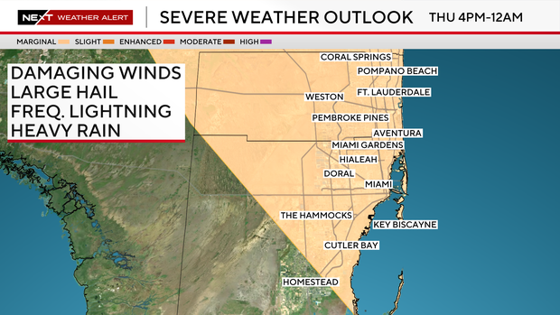
The Storm Prediction Center has Broward County and the Miami-Dade metro area at a marginal risk for isolated strong storms on Thursday and Friday afternoons.
The storms will form primarily in the afternoon and early evening hours. While the risk level is marginal, the lowest on the SPC’s five-tier scale, residents are urged to stay weather-aware, especially during peak storm times.
Outdoor plans and commutes could be impacted by sudden downpours or localized severe conditions.
In addition to storms, Thursday will be another hot day with temperatures in the lower to mid-90s and “feels like” temperatures in the triple digits.
NEXT Weather 
The heat continues through Memorial Day Weekend with afternoon highs in the low 90s, and “feels like” temperatures in the mid to upper 90s. The chance of rain is 30% for scattered showers.
As for rain, Cabrera said the sea breeze will no longer be pinned so storms will tend to form along the interior before working their way back to the coast. The chance of rain is 30% for scattered showers in the afternoon.


