South Florida is under a new NEXT Weather Alert Day this Saturday as the region braces for the potential of isolated strong storms, following a Friday that brought wind damage and hail to parts of Broward.
Late Friday night, the Storm Prediction Center increased the risk for severe weather across the region, prompting the update. While the Florida Keys have since been removed from Saturday’s threat zone, all of Broward County and most of Miami-Dade remain under elevated risk for severe conditions.
Hot, humid conditions could fuel Saturday storms
The NEXT Weather team says Saturday began warm and muggy, with heat index values expected to approach 100 degrees. Storm development is expected between 1 p.m. and 8 p.m., with a focus on areas further inland and near the Florida Everglades. However, some stronger storms may drift east into coastal and metro areas.
Damaging wind, hail, lightning, and heavy rainfall remain the main concerns. After sunset, the atmosphere is expected to stabilize, leading to a calmer and warmer evening.
CBS News Miami 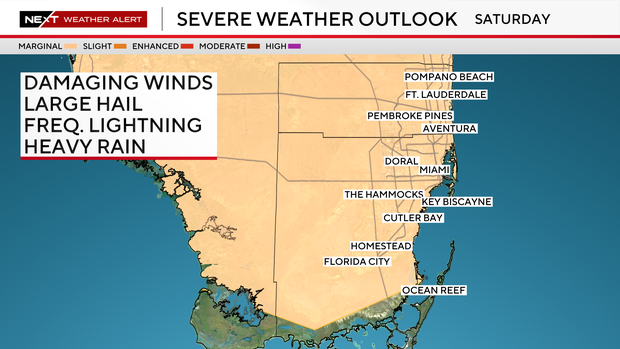
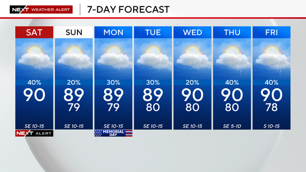
Miami, Broward Memorial Day weekend forecast
Looking ahead, isolated storm chances return Sunday but are slightly lower. By Memorial Day, rain chances increase to about 30% with afternoon highs staying in the upper 80s and low 90s through the holiday and into the next workweek.
CBS News Miami