
We’re in for a hot, humid and breezy start to the week, but a change is on the way.
Monday got off to a mild and muggy start with temperatures in the upper 70s across South Florida. It will be the hottest day of the week with highs soaring to the upper 80s in the afternoon. When the humidity is factored in, it will feel like the mid to upper 90s.
Although the chance of rain is low, a few showers will be possible in the afternoon and evening.
There is a moderate risk of rip currents along the Atlantic beaches due to the strong onshore breeze. Small craft should exercise caution over the Atlantic waters. There are no alerts or advisories for boaters in the Florida Keys.
On Tuesday, the chance of rain will be highest for the week due to a cold front that will bring plenty of moisture and lead to scattered showers and storms. Gusty downpours will be possible.
NEXT Weather
The National Weather Service Storm Prediction Center has placed southern Miami-Dade and the Keys under a Level 1 (marginal) risk for severe weather. We stay warm and muggy with highs in the mid 80s but cooler air will move in behind the front.
By Wednesday morning, it will be cooler and less humid. It will be in the mid 60s in the morning and afternoon highs will climb to around 80 degrees under mostly sunny skies with the potential for spotty showers.
Thursday will be cool again in the morning with lows in the mid 60s. It will be a pleasant and drier day with highs rising to 80 degrees.
NEXT Weather 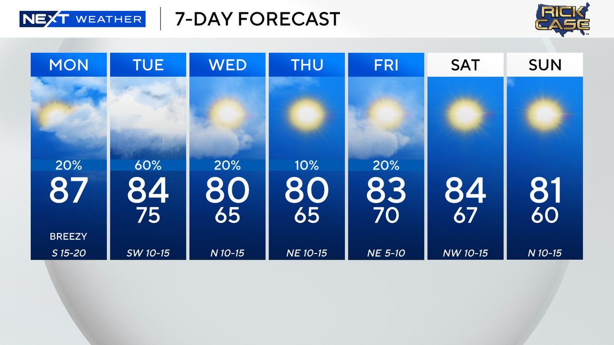
Friday will be slightly warmer with the potential for a few showers as a second cold front moves in.
A beautiful weekend is ahead as temperatures will fall to the upper 60s by Saturday morning with highs in the low 80s. Sunday morning will be the coldest start of the week as lows dip to 60 degrees and highs stay in the low 80s under mostly sunny skies.


