
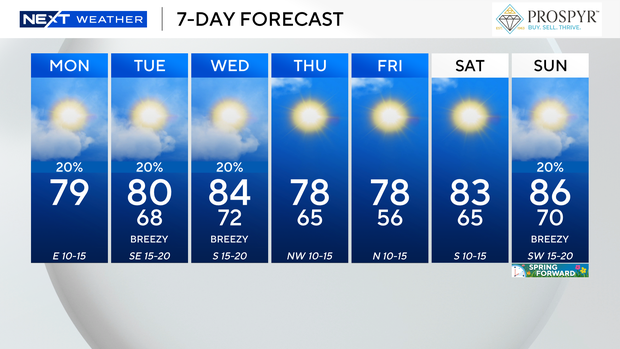
South Florida is waking up to milder temperatures in the low-to-mid 70s. A few showers have already popped up in spots. T
he breeze will build out of the east 15-to-20 mph with gusts over 20 mph at times. Hang on to your umbrella as quick spotty showers will blow in on the breeze. Highs climb to the upper 70s this afternoon.
There is a dangerously high risk of rip currents along the Atlantic beaches and hazardous marine conditions due to the strong onshore breeze. A small craft advisory is in effect for boaters in the Atlantic waters and small craft should exercise caution around the Keys.
Wednesday will be even warmer as highs soar to the low to mid 80s.
It will still be breezy and downright windy at times. Scattered showers will be possible but the chance of rain is not high.
Once the next cold front moves in, it will be cooler by Thursday morning with lows in the low-to-mid 60s. Highs will climb to the upper 70s.
It will feel even colder by Friday morning as lows fall to the low-to-mid 50s in Broward and Miami-Dade. Some inland areas could drop to the upper 40s. The Keys will wake up with a cool start too with lows in the 60s. The drier, cooler air will lead to a pleasant afternoon with lower humidity and highs in the upper 70s.
We warm right back up this weekend as highs rise to the upper 80s.
It will be breezy on Saturday and Sunday with low rain chances. We “spring forward” and turn clocks forward an hour Saturday night before bed as Daylight Saving Time begins Sunday at 2 a.m.
CBS News Miami


