MIAMI — Tropical Depression 14 has formed in the western Gulf of Mexico. It is forecast to strengthen into Tropical Storm Milton over the next 12 hours, then undergo a period of rapid intensification before it makes landfall as what is currently forecast to be a Category 2 hurricane across the west coast of Florida on Wednesday.
Most of South Florida is currently in the forecast cone.
K.C. Sherman
We will receive a “one-two punch” with this system, beginning tomorrow with a weaker and non-tropical area of low pressure that will swing through the area Sunday into Monday. This will bring our first round of heavy rain.
KC Sherman
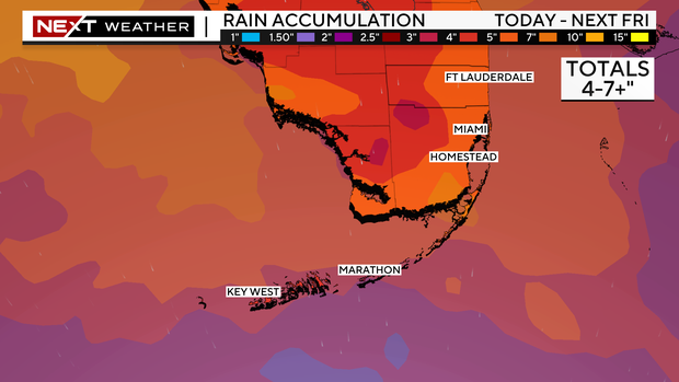
The second “punch” will be Milton, arriving Wednesday, which will bring more heavy rain and windy weather. For now, our main threat continues to be the risk of rainwater flooding, with 4″-7″+ looking likely across South Florida.
K.C. Sherman
Saturday will be a precursor to this stretch of very wet weather, with ongoing rounds of showers and storms set to move through the area. This will prime our soils for what will likely be an increasing flood risk set to continue into the week ahead.
K.C. Sherman
Remember, if you see standing water on the roadways, turn around! It only takes a foot of water to float most vehicles.


