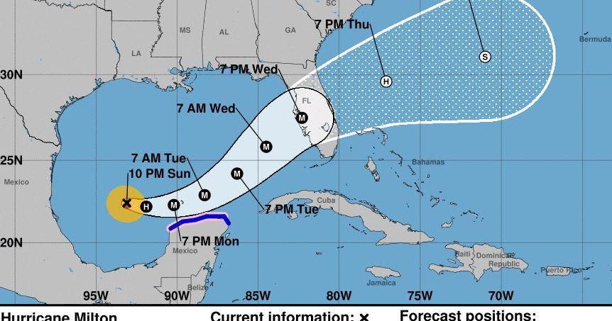
Milton strengthened into a Category 1 hurricane on Sunday afternoon with landfall forecast Wednesday afternoon as a major hurricane somewhere between Tampa and Fort Myers.
Virtually the entire state is in the National Hurricane Center’s cone path, including South Florida. As of 11 p.m., Milton was about 765 miles from Tampa with maximum sustained winds of 90 mph, just 6 mph from a Category 2.
CBS Miami NEXT Chief Meteorologist Ivan Cabrera said Milton is not a big threat to southeast Florida, including the Keys. It mainly will be high winds and rainfall.
Gov. Ron DeSantis has ordered a state of emergency in 51 of the 67 counties, including Miami-Dade, Broward and Monroe counties.
A flood watch is in effect through Thursday morning in South Florida. There is the risk of “considerable flash, urban and real flooding along with potential for moderate to major river flooding,” according to NHC.
Rainfall amounts of 5 to 10 inches, with localized totals up to 15 inches, are expected across portions of the Florida Peninsula and the Keys through Wednesday night, according to NHC.
Worsening weather overnight
Hurricane and storm watches could be required for portions of Florida overnight.
This will bring South Florida’s first round of heavy rain.
The storm will be slow to move and organize overnight before it is expected to speed up and intensify between Monday and Tuesday.
South Florida will receive a “one-two punch” beginning tonight with a weaker and non-tropical area of low pressure that will swing through the area then and into Monday, according to CBS News Miami’s NEXT Weather Team.
More heavy rain Monday
Milton is forecast to intensify into a major hurricane — at least a Category 3.
The lower pressure that will go through the area and heavy rain will continue.
The forecast highs are in the 80s with winds 10 to 15 mph. Lows in the upper 70s.
Showers continue Tuesday
Milton is forecast to become a Category 4 storm as it heads to Florida.
Showers will continue with highs in the mid 80s and winds 10 to 15 mph. Chance of rain 60%, according to the National Weather Service.
Lows in the upper 70s.
Landfall forecast Wednesday
Milton is forecast arrive on the Gulf Coast on Wednesday as a Category 2 storm, bringing more heavy rain and windy weather to South Florida, likely the most significant since the storm formed. Milton then is forecast pass through Central Florida and head to the Atlantic Ocean.
Depending on its track, Milton could bring tropical-storm conditions very early Wednesday for most of South Florida though the Florida Keys could see these conditions earlier.
South Florida’s main threat continues to be the risk of rainwater flooding, with 4 to 7 inches looking likely across the area.
Highs in the upper 80s and lows and lows in the mid 70s.
Better conditions Thursday
It will be cloudy with 40% chance of rain in the morning and 30% at night, according to the National Weather Service.
Highs in the upper 80s and lows in the mid 70s.


