
MIAMI – Passing showers and a few storms moved across parts of South Florida on Monday morning.
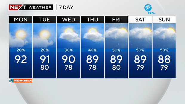
Although we woke to some rain in spots, it will be drier and hotter later in the day with highs climbing to the low 90s.
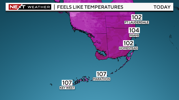
It will be a sizzling final day of September. Near-record heat will be possible in Miami. The forecast high is 92 degrees, the current record is 93 degrees set in 2023. The National Weather Service has issued a heat advisory for Miami-Dade and Broward through 6 p.m. due to forecast “feels like” temperatures of 105 to 110 degrees.
NEXT Weather
There is a moderate risk of rip currents along the Atlantic beaches. There are no alerts or advisories for boaters navigating the Atlantic and Keys waters.
The chance of rain remains low on Tuesday as high pressure remains in control and relatively drier air remains in place. A few showers will be possible. It will be a hot and humid start to the month of October with highs in the low 90s and feels like temperatures in the triple-digits. Another heat advisory will likely be issued.
On Wednesday the moisture will begin to increase and the chance of rain will start to rise with the potential for spotty showers.
NEXT Weather
Late week into the weekend the chance of rain will be at its highest. The CBS Miami NEXT Weather team is monitoring a large area of low pressure located over the western and southwestern Caribbean. The National Hurricane Center is giving this system a 40% chance of developing into a tropical depression over the next 7 days. This disturbance is forecast to move generally towards the northwest and into the Gulf of Mexico. Regardless of development, all the moisture associated with this system is expected to bring more wet weather to South Florida.


