
MIAMI – Tuesday will be a little warmer than Monday thanks to some added sunshine. Look for a few isolated showers from around 3 p.m. to 7 p.m. in the evening.
Beginning Wednesday, tropical moisture will surge back into South Florida as a warm front lifts northward up the Florida Peninsula. Look for higher chances of rain and storms, with heavy downpours and localized flooding possible.
NEXT Weather
Rain chances will remain elevated into Thursday with moisture sticking around. Thanks to the moisture, humidity will also be very high.
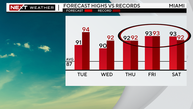
In fact, the high humidity will be coupled with highs running 4-6 degrees above average Thursday through Saturday, with record heat expected. Heat Advisories may be required late in the work week.
NEXT Weather
After some tough heat for the end of the week, all eyes will be on a cold front that is projected to move all the way through South Florida Sunday into next Monday. This looks like it will be our first real cold front of the season, with forecast models showing lows in the 60s and highs in the low to mid 80s by next Monday.
NEXT Weather meteorologist KC Sherman
Thanks for reading CBS NEWS.
Create your free account or log in
for more features.


