
MIAMI – A few showers moved moving across parts of South Florida on Friday morning. It was a warm start with temperatures in the upper 70s and low 80s.
NEXT Weather
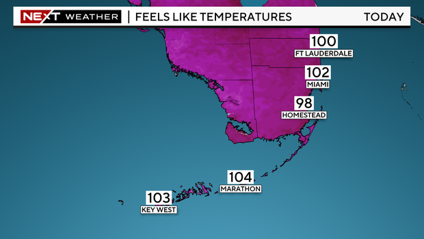
Near record heat is possible in the afternoon with highs in the low 90s. Passing showers will be possible throughout the day but the rain chance isn’t high.
This weekend we’ll return to more of a typical summertime pattern with scattered showers and some storms possible.
NEXT Weather
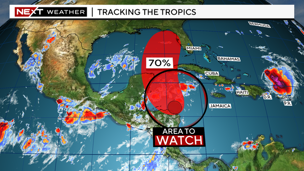
Early next week, our weather will depend on an area we are monitoring in the tropics. The CBS News Miami Next Weather team is tracking a broad area of low pressure producing disorganized showers and storms over the northwestern Caribbean. The National Hurricane Center is giving this system a 70% chance, a high potential, of becoming a tropical depression as it moves north into the Gulf of Mexico this weekend, as environmental conditions appear conducive for the gradual development of this system.
There is a lot of uncertainty regarding the exact forecast track and intensity as the models are not in agreement. Regardless of whether this develops into a tropical depression or tropical storm, all the moisture associated with this system is expected to bring us the potential for heavy rain and flooding since South Florida will be on the eastern side.
The timing of the heavy rain would likely be from late Monday through Wednesday all depending on how this evolves.
This weekend is a great time to review preparedness plans as we continue to monitor this disturbance and as we are in the peak of the Atlantic Hurricane Season.

Thanks for reading CBS NEWS.
Create your free account or log in
for more features.


