
MIAMI – We’re in for another round of storms on Monday.
The National Weather Service’s Storm Prediction Center has placed Broward and Miami-Dade under a marginal risk of severe weather. Although it is dry this morning, storms will develop later this afternoon and evening. Some storms could turn strong to severe with the potential for damaging wind gusts, lightning, heavy rain, and flooding.
NEXT Weather
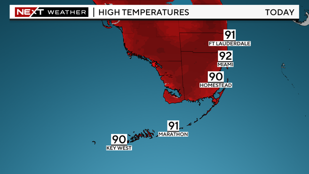
Highs climb to the low 90s and it will feel like the triple-digits when factoring in the high humidity. A Heat Advisory has been issued for the Florida Keys until 5 p.m. as heat indices will likely reach 108 to 112 degrees in the afternoon.
The heat is on the rest of the week with highs in the low 90s and the rain chance stays high with the potential for late-day storms.
NEXT Weather
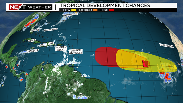
Tracking The Tropics
The CBS Miami Next Weather team is tracking two areas in the tropics. Invest 92-L in the Central Atlantic is better organized and has a high potential of becoming our next Tropical Depression. It is forecast to generally move westward over the next few days but there is some uncertainty regarding what path it will take this weekend as some forecast models indicate it may lift north while other models show it possibly moving west across the Lesser Antilles.
The other disturbance is located in the Eastern Atlantic, several hundred miles south of the Cabo Verde Islands, and has a low chance of development as it moves westward across the Central Tropical Atlantic.

Thanks for reading CBS NEWS.
Create your free account or log in
for more features.

