MIAMI – The CBS4 Weather team is busy tracking all the action in the tropics but there are no current threats to South Florida.
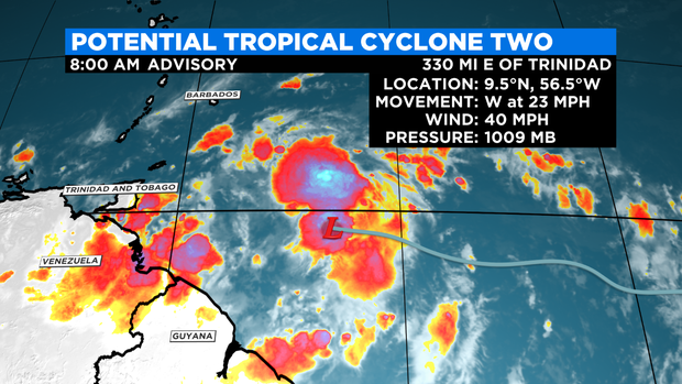
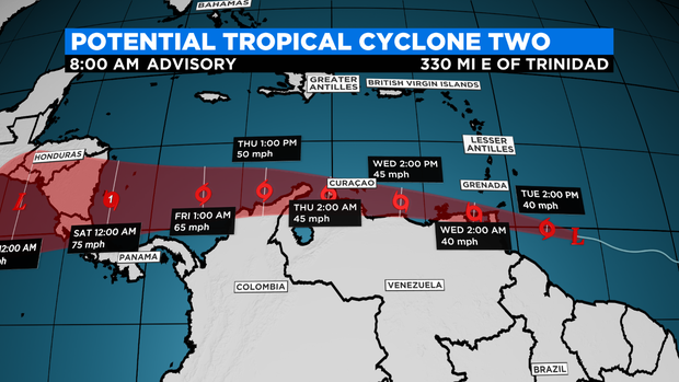
At 8 a.m., Potential Tropical Cyclone #2 was located about 330 miles east of Trinidad and moving west at 23 miles per hour. This disturbance is expected to strengthen into Tropical Storm Bonnie and bring heavy rain and gusty winds to the southern Windward Islands on Tuesday and Wednesday.
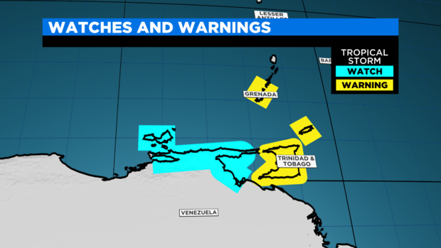
A Tropical Storm Warning is in effect for Trinidad and Tobago, Grenada and its dependencies. Tropical Storm conditions are expected across the southern Windward Islands Tuesday night. A Tropical Storm Watch is in effect from the coast of Venezuela from Pedernales to Cumana and Bonaire. Tropical storm conditions are possible in the watch area along the northern coast of Venezuela and nearby islands Tuesday night and in Bonaire by Wednesday evening.
This system is forecast to pass near or over portions of the southern Windward Islands by Tuesday night and then move over the southern Caribbean Sea or the northern coast of Venezuela on Wednesday and Thursday. Slight strengthening is forecast during the next few days if this disturbance remains over warm waters. It is forecast to become a Category 1 Hurricane possibly sometime this weekend before it heads towards Central America.
In addition to Potential Tropical Cyclone #2, there is an area of low pressure located over the northwestern Gulf of Mexico. Showers and thunderstorms associated with this low increased overnight but it remains disorganized. There is a low potential, 30% chance, of development as it moves generally westward at 5 to 10 miles per hour and approaches the coast of Texas during the next few days. There is a slight chance this wave may develop into a depression. Regardless of development, heavy rain and gusty winds will be possible along the coast of Texas later this week.
We are also monitoring a tropical wave in the central Atlantic located about 1,000 miles east of the Windward Islands. This disturbance remains disorganized and is forecast to interact with another tropical wave to the east over the next several days. Some gradual development is possible later this week while the overall system moves west-northwestward at around 15 miles per hour. The National Hurricane Center is giving this wave a low potential, 20% chance, of development over the next 5 days.